2023.08.03.20
Files > Volume 8 > Vol 8 No 3 2023
The REDATAM program: an approach to the Sustainable Development Goals in the Galapagos Islands

Marco Heredia-R 1*, Mateo Acurio-Gallardo2, Emma Torres 1, Jamil Heredia-Silva 3,4,5, Paterson Loyola-Barbosa6, Alexandra Torres 7, Karolina Villacis8, Theofilos Toulkeridis 9
1 Facultad de Ciencias Pecuarias y Biológicas, Universidad Técnica Estatal de Quevedo (UTEQ), Av. Quito km 11/2 vía a Santo Domingo de los Tsáchilas, Quevedo 120550, Ecuador.
2 Turismo Sostenible y TIC, Universitat Oberta de Catalunya (UOC) Barcelona, 08018 España.
3 Instituto Superior Tecnológico Vicente León, Latacunga, Cotopaxi, 050102, Ecuador.
4 Maestría en Educación e Innovación, Universidad Politécnica del Carchi (UPEC). Av Universitaria. Tulcán, Carchi, 040110, Ecuador.
5 Doctorado en Educación, Facultad Humanidades y Educación, Campus Montalbán, Caracas 1000, Distrito Capital, Venezuela.
6 Programa en Gestión Ambiental con mención en Desarrollo Sostenible, Universidad Técnica de Cotopaxi, Latacunga 0501491 Ecuador.
7 Facultad de Ciencias Jurídicas, Sociales y de la Educación. Universidad Técnica de Babahoyo. Extensión Quevedo (UTB). Km 3 1/2 Vía a Valencia, Los Ríos 120550, Ecuador.
8 Maestría en Administración de Empresas, Universidad Técnica de Cotopaxi, Latacunga 0501491 Ecuador.
9 Departamento de Ciencias de la Tierra y Construcción, Universidad de las Fuerzas Armadas ESPE, Sangolquí 171103, Ecuador.
*Correspondence: [email protected] (MH-R)
Available from. http://dx.doi.org/10.21931/RB/2023.08.03.20
ABSTRACT
Computer programs are an essential ally for fulfilling the Sustainable Development Goals (SDGs). They offer enormous potential for accelerating said fulfillment and reducing the cost of implementation processes. Our objectives in this Galapagos Islands case study were: i) to quantify the proportion of male and female inhabitants, separated by ethnicity, ii) to identify the number of dwellings distributed at urban and rural levels according to their typology, and iii) to determine the proportion of dwellings that are supplied with water. The Galapagos Islands are located 1000 km from mainland Ecuador. The program used was REDATAM Version 7 (Microcomputer Data Recovery for Small Areas), which specializes in processing microdata from population and housing censuses. The unit of investigation was the dwellings, and within them, the households and household members who are habitual residents in the province of Galapagos and who were in the 2015 census. It was identified that at the provincial level, 51.20% are male and 48. 80% are female, and the most populous canton is Santa Cruz. The population is divided into six ethnic groups heterogeneously between urban and rural sectors and between cantons. There are no group housing projects at the rural level for preventive or remedial assistance for the population, and there is a deficit in terms of water supply to the rural sector. Therefore, local authorities must promote programs to improve the living conditions of rural and urban dwellers to work toward complying with the goals of the Sustainable Development Goals, as outlined in the 2030 Agenda.
Keywords: 2030 Agenda; census, development, demography sustainable.
INTRODUCTION
New computational technologies and paradigms can be employed in various fields, including demography, natural resource protection, agriculture, etc.2-9. The use and management of technology devices constitute one option for streamlining work in various areas 10. The use of computer programs can enable teaching and learning processes aimed at the construction of meaningful learning and public policies11.
The contribution of the extensive use of computer programs and censuses has spread in the generation of specific social impacts such as improving the quality of education, ensuring healthy lives, strengthening economic growth, and generating high-quality jobs12. However, from a sustainable perspective, the need arises to use these technologies to solve problems such as poverty, exclusion, economic and social development, and climate change, associating them with the rational use of the resources provided by nature13.
Population and housing censuses are a primary tool that should be considered to combat the challenges of obtaining essential information for sustainable development at local, regional, and national levels15,14. Its universal scope – i.e., it involves every single person residing in a territory, the households to which they belong, and the dwellings they inhabit16 – enables the obtaining of vital information concerning the living conditions of the population for smaller geographic areas and small populations groups, without the errors attributable to other sources of information that include samples in their design17.
Census processes constitute a fundamental means of identifying the populations that should be at the center of sustainable development policies, considering their implications on their demographic dynamics18,19. Censuses are an essential source for defining baselines for the starting dates for monitoring the goals and indicators of the 2030 Agenda. They will also be responsible for recording progress towards 2030, the year the goals should be achieved and the time for a new round of censuses20,21.
In 1985, the first version of the REDATAM DOS program was generated to identify and locate all census tabulations and publications, both general and specific22. To date, five versions have been created23; the REDATAM 7 program is the latest version published (2014), under the operating system, environment, and platform of Windows, WebServer, 64 bits, and Unicode-multilingual25. The development of REDATAM 7 had three main objectives: i) to increase the data processing speed, ii) to facilitate the programming of indicators, and iii) to improve the user's technical experience 24.
The latest studies using REDATAM have been about COVID-19 mortality and inequalities by socioeconomic level and territory across Latin America and the Caribbean26; quantifying the statistical evidence of COVID-19 in Costa Rica27; verifying the versatility in the adjustment of complex statistical models (in conjunction with the R program)28; statistical applications and processing tests carried out with the various versions of REDATAM29; microdata from the last 4 official censuses in Chile used to generate indicators30; and so on. Based on this background, the objectives were: i) to quantify the proportion of male and female inhabitants, separated by ethnicity, ii) to identify the number of dwellings distributed at urban and rural levels according to their typology, and iii) to determine the proportion of dwellings that are supplied with water. Finally, the document presents potential policy implications with a focus on technology.
MATERIALS AND METHODS
Geographic Location
The study area was the Galapagos Islands, located 1000 km from mainland Ecuador (Figure 1), the second most volcanically active archipelago, surpassed only by Hawaii31. The Galapagos were declared a national park in 1959, protecting 97.5% of the archipelago's land area; the remaining area is occupied by human settlements32,33. The archipelago has several international agreements implemented to try to guarantee the conservation of the Galapagos, including a World Heritage Site, Ramsar Site, Whale Sanctuary, and Biosphere Reserve. The World Conservation Strategy identifies the Galapagos as a priority biogeographic province for establishing protected areas; the cold Humboldt Current and the warm Panama Current34 influence its climate.
The population is 25,244, distributed between the islands of San Cristóbal (28.51%), Isabela (9.29%), and Santa Cruz (62.20%). By self-denomination, according to culture, we find that 85% are Mestizos, 8% are Indigenous, 6% are Afro-Ecuadorians or white, and 1% are Montubios. The average age among the inhabitants is 29.3 years, and the dependency rate is 46.6%. Illiteracy stands at 1.3%35.
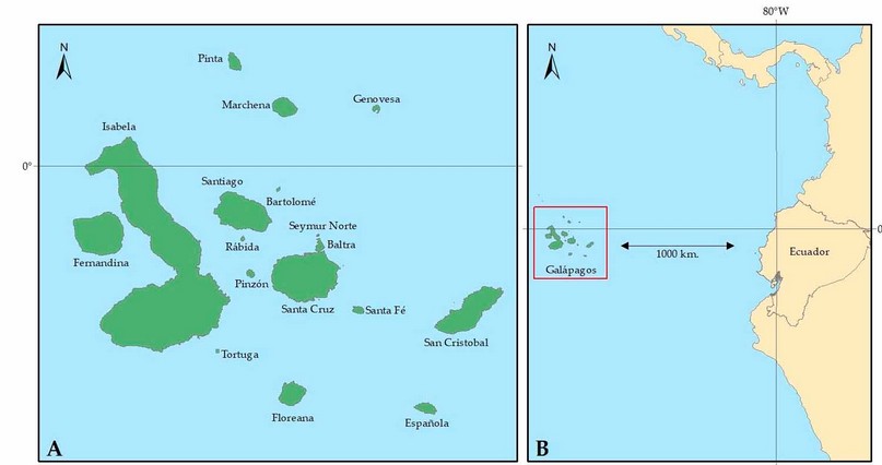
Figure 1. Study area: A) Spatial distribution of the islands belonging to the province of Galapagos, and B) Location of Galapagos concerning mainland Ecuador.
Software
The software used was REDATAM Version 7, fifth generation (https://REDATAM.org/es/aplicaciones). Its acronym in Spanish means Microcomputer Data Recovery for Small Areas. The program was developed in 2015 and maintained by the Latin American and Caribbean Demographic Center (CELADE, Population Division of ECLAC)22. REDATAM 7 is a statistical processing software specialized in microdata from population and housing censuses, surveys, and vital statistics. The program synthesizes large volumes of data, has a high processing speed35, and has been used in more than 30 countries in the Americas, Africa, and Asia35.
REDATAM databases are highly compressed and have a hierarchical structure with a geographic breakdown into more minor levels, such as city blocks, which enables local, regional, or national analysis. The program incorporates a development technology based on C++, Delphi, Java, and JavaScript37.
Census data
For this research, the 2015 census data for the Galapagos province (https://anda.inec.gob.ec/anda/index.php/catalog/553/study-description) was used, conducted in both urban and rural areas, where information was collected on all existing dwellings and the population that usually resides in the province. The unit of investigation was the dwellings and, within them, the households and household members who are habitual residents in the Galapagos province.
Due to the complexity of the study area, the information was collected over one month – from November 5th to December 2nd, 2015 – using mobile capture devices (Tablet) and by directly interviewing a qualified informant, such as the head of household, spouse, or household member aged 12 years and older, who knows and can provide information on all members of the family. Only in exceptional cases physical questionnaires were used35.
Data Management
The organization of the census data was based on nine entities, which are sets of logical objects organized hierarchically in the database (Figure 2) and three elements that are the individual members of each entity38.
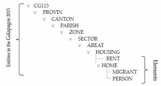
Figure 2. REDATAM 7 interface: the Galapagos 2015 database, with nine entities and three hierarchically organized elements.
To meet each objective, we applied cross-referenced variables, consisting of information about the elements that comprise an entity and a database. A census database stores information in variables, such as people's sex, kinship, age, the dwellings' type of roof and wall, and the millimeters of rainfall in the communes38.
For Objective 1 (proportion of male and female inhabitants at the urban-rural level (1) and ethnicity (2)), the following equations were used:
TABLE FREQ CANTON.NAMEOFCANT BY PERSON.SEX (1)
TABLE FREQ CANTON.NAMEOFCANT BY VIVIENDA.AUR BY PERSON.P06 (2)
For Objective 2 (number of dwellings distributed at the urban and rural level according to their typology), we used:
TABLE FREQ HOUSING.VTV BY HOUSING.AUR (3)
For Objective 3 (proportion of dwellings supplied with water), we used:
TABLE FREQ HOUSING.V05 BY HOUSING.AUR (4)
RESULTS
The proportions and distributions of the population by sex, ethnicity, housing type, and water supply on the Galapagos Islands.
The proportion of male and female inhabitants at urban and rural levels
At the provincial level, 51.20% are male and 48.80% are female (Table 1). At the cantonal level, Santa Cruz is the most populated (62.20%), followed by San Cristóbal (28.52%) and Isabela (9.29%). The canton with the most significant female presence is Santa Cruz (30.51%), while in San Cristóbal and Isabela, female people make up 13.81% and 4.48% of the population, respectively. 50.95% are male in Santa Cruz, and 51.59% and 51.71% in San Cristóbal and Isabela, respectively.
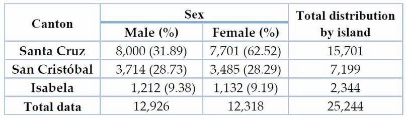
Table 1. The proportion of male and female inhabitants on the Galapagos Islands in 2015
Regarding population distribution by sector (urban-rural) and ethnicity (Table 2), the urban sector has the highest concentration of population (81.36%). In contrast, the rural population is distributed between Santa Cruz, San Cristóbal, and Isabela with 82.44%, 13.73%, and 13.73%, respectively. In terms of ethnicity in the archipelago, Mestizos (85.18%) form the largest group by far, followed by Indigenous people (8.07%), Afro-Ecuadorians (2.83%), white people (2.63%), Montubios (1.25), and others (0.04%) (Table 2).
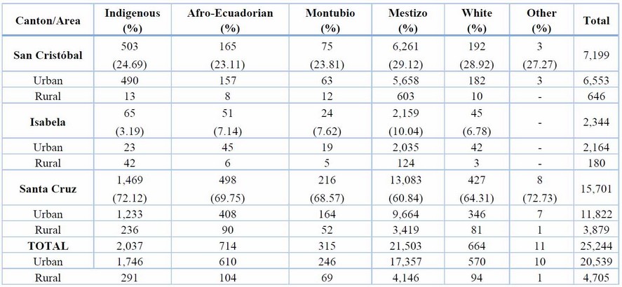
Table 2. Population distribution by sector and ethnicity on the Galapagos Islands in 2015 and proportion in parenthesis.
Number of dwellings distributed at urban and rural levels according to type in the Galapagos Islands
At the provincial level, 97.40% of the dwellings are private homes, while 2.60% are group dwellings (Table 3). At the urban level, there are more apartments in houses or buildings (49.62%), followed by villa houses (34.46%), while in rural areas, there are more villa houses (79.13%) than apartments (8.06%).
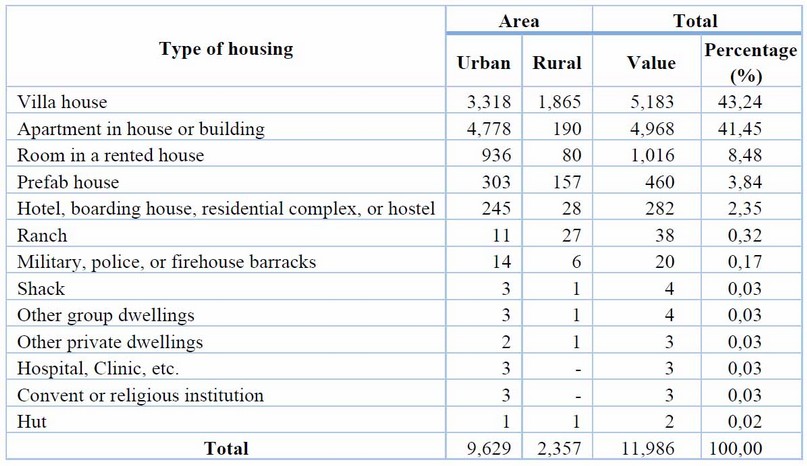
Table 3. Housing typology by sector on the Galapagos Islands in 2015
The proportion of households supplied with water on the Galapagos Islands.
At the provincial level, water supply is provided by the public water mains (89.92%), rainwater (5.20%), water delivery trucks (3.88%), rivers or irrigation channels (0.65%), and wells (0.35%) (Table 4). At the rural level, the principal means of water supply are rainwater collection (29.79%), water delivery trucks (14.97%), and rivers or irrigation channels (2.97%), while at the urban level, the public water mains (97.91%), water delivery trucks (1.55%), and wells (0.35%) predominate as water supply mechanisms.
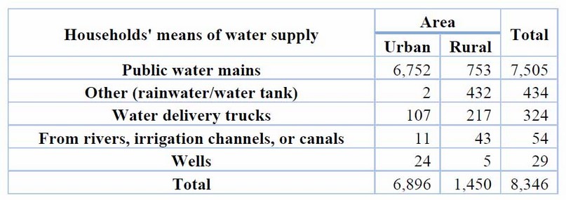
Table 4. Households and their means of water supply on the Galapagos Islands in 2015.
DISCUSSION
On the Galapagos Islands, there are more male than female residents (by 2%). Compared to other island areas, its population represents 1.2% of the Canary Islands' population (Spain)39 and 14% of the Chiloé archipelago's population (Chile)40. Migration is a social process that alters a given population's structure, growth, and distribution and is fundamentally linked to social, economic, and political factors, leaving considerable gaps in both the place of origin and destination41. The different migratory processes to the Galapagos Islands have meant that the land is occupied by various ethnic groups: Indigenous, Afro-Ecuadorian, Montubio, Mestizo, and white people42-45. Similar scenarios have occurred in the Canary Islands, where citizens from Venezuela, Cuba, Germany, Morocco, Ivory Coast, Guinea, Gambia, Senegal, and Cameroon have arrived 46.
Group housing is intended to be inhabited by people subject to a joint authority or regime not based on family ties or cohabitation. Group housing may only partially occupy a building or, more frequently, the entire building 35. 12% of group housing in the Galapagos is in rural areas, while 88% is in urban areas, of which 1% are hospitals, clinics, etc., 5% are military, police, or firehouse barracks, and 91% are hotels, residential complexes, and hostels. This is contrary to Target 3.3.8 of SDG 3, "Achieve universal health coverage, including financial risk protection, access to quality essential healthcare services and access to safe, effective, quality and affordable essential medicines and vaccines for all," as there is no evidence of essential hospitals in the rural areas of the islands47.
More than 2 million people die each year from diarrheal diseases worldwide48-49, and a lack of hygiene and unsafe water are responsible for almost 90% of these deaths, mainly affecting children47. At the rural level in Galapagos, a mere 8% (907) of households have access to water. Given the abovementioned issues, it is essential to meet target 6.6. a of SDG 6, "By 2030, expand international cooperation and capacity-building support to developing countries in water- and sanitation-related activities and programs, including water harvesting, desalination, water efficiency, wastewater treatment, recycling and reuse technologies" 47.
One of the most common and complicated problems faced by rural communities around the world relates to inadequate conditions for accessing drinking water, circumstances exacerbated by the gradual decrease in water resources and the consequent increase in the costs of obtaining drinking water51. The availability of drinking water in the world is very variable and is directly related to poverty and the inability of governments to finance sanitation projects; thus, regions such as Africa, Asia, Latin America, and the Caribbean have around one billion people in rural areas who do not have access to improved water sources52. The problem of being unable to access an adequate drinking water supply is exacerbated by long periods of drought53. On the Galapagos Islands, of the total number of households (8,346) that have some water supply in rural areas, 17% receive water from the public water mains, while the rest collect water from wells, the rain, irrigation channels, or water delivery trucks that possibly there is bacterial contamination that exceeds the permissible limit, a scenario similar to areas far from the center of the city of Karbala (Iraq), where bottled water is contaminated54. To avoid problems related to water stress and public health, it is essential to use a natural carbon filter and solar disinfection as alternatives for more significant removal of contaminants51-53.
Potential technological policy implications with REDATAM
One of the main policy implications of REDATAM is its ability to democratize access to information56. Previously, access to census and socioeconomic data was limited to experts and government officials, hindering citizen participation in decision-making processes, such as census data from the Galapagos Islands. REDATAM has allowed anyone with access to a computer to easily explore and analyze the data, empowering civil society and fostering transparency in political processes.
In addition, REDATAM has facilitated the creation of evidence-based public policies 58. Thanks to its capacity to process large volumes of data and generate automatic tabulations, decision-makers can obtain up-to-date and detailed information on the socioeconomic situation; for example, gaps and inequalities have been identified in this case study of the Galapagos Islands. Furthermore, REDATAM has promoted a culture of evaluation and monitoring of public policies, as the results of interventions can be systematically monitored and evaluated 59.
Nevertheless, challenges and potential risks are also associated with using REDATAM in the political arena. One of these is the proper handling of privacy and data protection60. When working with sensitive information, it is essential to guarantee the data's confidentiality and protect the people's identity. In addition, the availability of detailed and accessible information can pose challenges in national security, as specific data could be misused or maliciously61.
Another challenge is to ensure that access to REDATAM is inclusive and equitable. Although the tool has contributed to democratizing access to information, ensuring that all people have the necessary training and resources to use it effectively, 56 is necessary. Moreover, it is essential to address the digital divide, ensuring that the most marginalized and disadvantaged communities also have access to technology and can benefit from REDATAM.
CONCLUSIONS
The population distribution identified by ethnicity and sex at rural and urban levels in the cantons of the Galapagos Islands could promote capacity-building campaigns for key groups for parish, cantonal, and provincial councils. The higher number of group dwellings in urban as opposed to rural areas in the Galapagos Islands is of concern regarding public healthcare for villagers and farmers. The precarious water coverage at the rural level could cause potential illnesses, increased livelihood costs, and further migration to the urban sector.
The REDATAM program facilitates the management of census data at the country and sector level, facilitating the construction of various indicators and targets relating to the Sustainable Development Goals and thus contributing to decisions made by sectoral governments. REDATAM has had essential policy implications by democratizing access to information and strengthening evidence-based decision-making. However, it is essential to address the challenges associated with using this tool, such as data protection and equity of access, to ensure that its benefits are used responsibly and moderately.
Author Contributions: “Conceptualization, M.H-R. and E.T.; methodology, M.H-R. and E.T.; software, M.H-R.; A.T.; formal analysis, M.H-R. and K.V.; investigation, M.H-R. and P.L-B.; data curation, M.A-G.; J.H-S.; writing—original draft preparation, M.H-R.; E.T.and A.T.; writing—review and editing, M.H-R.;T.T; visualization, M.A-G.; J.H-S.; supervision, T.T.; project administration, M.H-R.; All authors have read and agreed to the published version of the manuscript.
Funding: This research received no external funding.
Data Availability Statement: Data are available through the corresponding author.
Acknowledgments: We want to thank the Technical University of the State of Quevedo (Los Ríos, Ecuador) and CONAGOPARE Galapagos for the support in carrying out this research and for the small grant of the project: Evaluation of agroecological dynamics and climate change in producers in Galapagos
Conflicts of Interest: "The authors declare no conflict of interest."
REFERENCES
1. Quezada-Sarmiento P A, Mengual Andrés S. Implementación de una solución web y móvil para la gestión vehicular basada en Arquitectura de Aspectos y metodologías ágiles: Un enfoque educativo de la teoría a la práctica. RISTI Revista Ibérica de Sistemas y Tecnologías de Información, 2017. 27, 97–111 doi https://scielo.pt/pdf/rist/n25/n25a08.pdf
2. Heredia-R M, Torres B, Cabrera-Torres F, Vasco E, Díaz-Ambrona CGH, Toulkeridis T. Free Data Processing Applied to Detect Changes in Land Use Coverage at Biodiversity Hotspots of the Amazon. In: Berrezueta, S., Abad, K. (eds) Doctoral Symposium on Information and Communication Technologies - DSICT. Lecture Notes in Electrical Engineering, 2022 vol 846. Springer, Cham. https://doi.org/10.1007/978-3-030-93718-8_9 2022.
3. Heredia-R M, Cayambe J, Schorsch C, Toulkeridis T, Barreto D, Poma P, Villegas G. Multitemporal Analysis as a Non-Invasive Technology Indicates a Rapid Change in Land Use in the Amazon: The Case of the ITT Oil Block. Environments 2021, 8, 139. https://doi.org/10.3390/environments8120139
4. Heredia-R M, Torres B, Cabrera-Torres F, Torres E, Díaz-Ambrona CGH, Pappalardo SE. Land Use and Land Cover Changes in the Diversity and Life Zone for Uncontacted Indigenous People: Deforestation Hotspots in the Yasuní Biosphere Reserve, Ecuadorian Amazon. Forests 2021, 12, 1539. https://doi.org/10.3390/f12111539
5. Toulkeridis T, Seqqat R, Torres Arias M, Salazar-Martinez R, Ortiz-Prado E, Chunga S, et al. Volcanic Ash as a Precursor for SARS-CoV-2 Infection Among Susceptible Populations in Ecuador: A Satellite Imaging and Excess Mortality-Based Analysis. Disaster Medicine and Public Health Preparedness. Cambridge University Press; 2021;:1–13.
6. Heredia-R M, Torres B, Cayambe J, Ramos N, Luna M, Diaz-Ambrona, CGH. Sustainability Assessment of Smallholder Agroforestry Indigenous Farming in the Amazon: A Case Study of Ecuadorian Kichwas. Agronomy 2020, 10, 1973. https://doi.org/10.3390/agronomy10121973
7. Barreto-Álvarez DE, Heredia-Rengifo M, Padilla-Almeida O, Toulkeridis T. Multitemporal Evaluation of the Recent Land Use Change in Santa Cruz Island, Galapagos, Ecuador. In: Rodriguez Morales, G., Fonseca C., E.R., Salgado, J.P., Pérez-Gosende, P., Orellana Cordero, M., Berrezueta, S. (eds) Information and Communication Technologies. TICEC 2022. Communications in Computer and Information Science, vol 1307. Springer, Cham. https://doi.org/10.1007/978-3-030-62833-8_38
8. Heredia-R M, Torres B, Vasseur L, Puhl L, Barreto D and Díaz-Ambrona CGH Sustainability Dimensions Assessment in Four Traditional Agricultural Systems in the Amazon. Front. Sustain. Food Syst. 5:782633. 2022 doi: 10.3389/fsufs.2021.782633
9. Torres B, Andrade A, Enriquez F, Luna M, Heredia-R M, Bravo C. Estudios sobre medios devida, sostenibilidad y captura de carbono en Chakra con cacao:casos de las asociaciones Kallari, Wiñak y Tsatsayaku, Amazonía Ecuatoriana. FAO - Ecuador. 2022. 137 pp
10. Razo Salas M A, Vázquez-Reyes S, Solís-Robles R. Mejoras del proceso endoscópico usando aplicaciones móviles. RISTI Revista Ibérica de Sistemas yTecnologías de Información, 2016. 17, 115–127
11. Coll C and Monereo C. Psicología de la Educación Virtual. Madrid: Ediciones Morata 2008.
12. Ziemba E. The Contribution of ICT Adoption to the Sustainable Information Society. Journal of Computer Information Systems, 2017 00(00), 1-11. http://doi.org/10.1080/08874417.2017.1312635 2017.
13. Ibujés Villacís JM, y Franco Crespo AA. Uso de las TIC y relación con los Objetivos de Desarrollo Sostenible en Ecuador. Retos Revista de Ciencias de la Administración y Economía, 2019 9(17), 37-53. https://doi.org/10.17163/ret.n17.2019.03 2019.
14. Lopes VF. Los censos de población y vivienda: críticas y sugerencias. Notas de población 1981.
15. Feres JC, & Espina R. Medición de la pobreza a través de los censos de población y vivienda. En: Los censos de 2010 y las condiciones de vida: informe del seminario-taller. Santiago: CEPAL, 2011. p. 321-328. LC/L. 3282-P.
16. Schkolnik S. Acerca de la inclusión del enfoque de género en los censos de población y vivienda. En: Los censos de 2010 y la salud: informe del seminario-taller. Santiago: CEPAL, 2010. p. 49-84. LC/L. 3253.
17. Aliaga Linares L. Las características educativas en los censos de población y vivienda de América Latina. Notas de Población 2011.
18. CEPAL N. Guía para la elaboración de un proyecto censal. Centro Latinoamericano y Caribeño de Demografía (CELADE) – División de Población de la CEPAL 2011.
19. Díaz Parra I, & Apaolaza R. Una propuesta metodológica para identificar gentrificación a partir de los censos de población. Estudios demográficos y urbanos, 2020. 35(3), 629-661.
20. CEPAL N. Recomendaciones para los censos de población y vivienda en América Latina. Revisión 2020. 2021.
21. Schkolnik S, & Del Popolo F. Pueblos indígenas y afrodescendientes en los censos de población y vivienda de América Latina: avances y desafíos en el derecho a la información. Notas de población 2013.
22. De Grande P. “El formato REDATAM”. Estudios. demográficos. urbanos 2016, vol.31, n.3. ISSN 2448-6515.pp.811-832. Disponible en: http://www.scielo.org.mx /scielo.php?script=sci_a rttext&pid=S0186-72102016000300811&lng=es&nrm=iso.
23. Veizaga JM. Enseñar y aprender demografía a través de la difusión del REDATAM: contextos, avances, limitaciones, implicaciones y perspectivas 2016.
24. CEPAL N. Informe de actividades del Centro Latinoamericano y Caribeño de Demografía (CELADE), División de Población de la CEPAL durante el período 2010-2012. 2012.
25. CEPAL N. Report of the working group of censuses of the statistical conference of the Americas of ECLAC. 2011.
26. Cruz Castanheira H. and Monteiro da Silva JH. “Mortalidad por COVID-19 y las desigualdades por nivel socioeconómico y por territorio. Enfoques. Edición del Boletín No 26. CEPAL, 2021.. https://www.cepal.org/es/publicaciones/tipo/REDATAM-informa/26-0
27. Bonilla J. Evidencia estadística de la Covid-19 en Costa Rica a través de la herramienta REDATAM”Enfoques. Edición del Boletín No 26. CEPAL, 2021. https://crm.cepal.org/civicrm/mailing/view?reset=1&id =347\#art 2
28. Gutiérrez A, Guerrero S, Lemus D and Molina F. “La librería REDATAM de R en el ajuste de modelos de estimación en áreas pequeñas” REDATAM” Enfoques. Edición del Boletín No 26. CEPAL, 2021. https://crm.cepal.org/civicrm/mailing/view?reset=1&id=1347 #art2
29. Araujo M. “La experiencia de trabajar con REDATAM en estadísticas basadas en Registros Administrativos”Enfoques. Edición del Boletín No 26. CEPAL, 2021. https://crm.cepal.org/civicrm/ma iling/view? reset=1 & id=1347#art2
30. Rodríguez-Vignoli J. “Concentración en el Gran Santiago y migración: población, vivienda y recursos humanos 1977-2017”. Revista EURE-Revista de Estudios Urbano Regionales, (2022).48(143).
31. Toulkeridis T, Angermeyer H. Volcanoes of the Galapagos. 2nd ed. Guayaquil, Ecuador: Abad Offest; 2019. 324 pp
32. González JA, Montes C, Rodríguez J, and Tapia W. “Rethinking the Galapagos Islands as a complex social-ecological system: implications for conservation and management”. Ecology and Society, 2008. 13(2).
33. Ospina P. “Migraciones, actores e identidades en Galápagos”. Instituto de Estudios Ecuatorianos/CLACSO/ASDI Inédito. Quito. 2001.
34. Mackinnon J, Mackinnon K, Child G, Thorsell J. Manejo de áreas protegidas en los trópicos. Gland, Suiza: Unión Internacional para la Conservación de la Naturaleza y los Recursos Naturales (UICN)–Programa de las Naciones Unidas para el Medio Ambiente (PNUMA). 314 pp., 1990.
35. INEC. Censo de Población y Vivienda – Galápagos. Instituto Nacional de Estadística y Censos. Quito, Ecuador. 2015
36. D. Jaspers. S. Poulard “El software REDATAM para divulgación y análisis de datos censales”, Notas de Población 29(75) 2022 pp.321-341.
37. CEPAL, REDATAM informa, diciembre 2011: 25 años de desarrollo del software REDATAM. 2011, https://REDATAM.org/es/novedades, Accessed June 25, 2022.
38. REDATAM. ¨Red7 Create¨ aplicación informática del Centro Latinoamericano y Caribeño, de Demografía (CELADE) CEPAL. 2015. Disponible en: https://REDATAM.org/cdr/manuales/red7/esp/Red7-01-Create-ESP.pdf
39. INE. Instituto Nacional de Estadística 2020 Disponle en: www.ine.es
40. INE Instituto Nacional de Estadísticas 2017 Disponible en: https://www.ine.cl/
41. Gutiérrez JM, Borré JR, Montero RA, and Mendoza XFB. Migración: Contexto, impacto y desafío. Una reflexión teórica. Revista de Ciencias Sociales, 2020 26(2), 299-313.
42. Granda LM y Salazar GC. Población y migración en Galápagos. 2013 Pp. 44-51. En: Informe Galápagos 2011- 2012. DPNG, GCREG, FCD y GC. Puerto Ayora, Galápagos, Ecuador.
43. Astudillo F, Becerra E, Delgado F, Jamieson R, and Stahl PW. "When the Archaeologists Leave: Legacies and Services of the Historical Ecology of the Galápagos Islands Project." Advances in Archaeological Practice, 2023, 1–11. doi:10.1017/aap.2023.8.
44. Ahassi C. Lo Galapagueño, los Galapagueños. Proceso de construcción de identidades en las islas Galápagos. 2007. Antropología Experimental, (7).
45. Aguilar-López BP, & Guerra Velasteguí JA. Movilidad humana y turismo: Estudio sobre la transición de turista a residente de los tres mercados principales que ingresan a Ecuador (2020). (Bachelor’s thesis, Quito: UCE).
46. Caicedo Riascos M. Nota sobre “Rutas migratorias y nuevos espacios de frontera: el caso de las Islas Canarias”, ponencia presentada por Ana María López. Estudios demográficos y urbanos, 2005. 20(2), 387-393.
47. UN, Naciones Unidas, ODS, Objetivo 3: Garantizar una vida sana y promover el bienestar para todos en todas las edades, Disponible en https://www.un.org/sustainabledevelopment/ es/health/ 2015.
48. Bollyky TJ. Oral Rehydration Salts, Cholera, and the Unfinished Urban Health Agenda. Tropical Medicine and Infectious Disease, 2022. 7(5), 67.
49. Liu L, Villavicencio F, Yeung D, Perin J, López G, Strong KL y Black RE. Causas nacionales, regionales y mundiales de mortalidad en personas de 5 a 19 años de 2000 a 2019: un análisis sistemático. The Lancet Global Health, 2022. 10 (3), e337-e347.
50. Hernández Avilés DM, y Chaparro T. “Tratamiento de agua lluvia con fines de consumo humano”, Cien. Ing. Neogranadina, vol. 30, n.º 2, ago. 2020.
51. Malato S, Fernández-Ibáñez SP, Maldonado MI, Blanco J, y Gernjak W. "Decontamination and disinfection of water by solar photocatalysis: recent overview and trends", Cat. Today, 14 (1), 2009. pp. 1-59. doi: 10.1016/j.cattod.2009.06.018.
52. Gelover S, Gómez LA, Reyes K, and Leal Ma. "A practical demonstration of water disinfection using TiO2 films and sunlight water", Wat. Res., 2006 20 (17), pp.3274-3280. doi: 10.1016/j.watres.07.006.
53. Mankad A. "Decentralised water systems: Emotional influences on resources decision making", 2012 Env. Int., vol. 44, n.° 1. pp.128-140, 2012. doi: 10.1016/j.envint.2012.01.002
54. Hussein Hassan S, Khalaf Ali J. Study the quality of drinking water in the holy city of Karbala. Revis Bionatura 2022;7(2) 26. http://dx.doi.org/10.21931/RB/2022.07.02.26
55. Nickisch MB, Sánchez L, Tosolini R, Díaz FT, and Jordan P. Sistemas de captación de agua de lluvia para consumo humano, sinónimo de agua segura. Aqua-LAC, 2018. 10(1), 15-25.
56. Canton H. Economic Commission for Latin America and the Caribbean—ECLAC. In The Europa Directory of International Organizations 2021 (pp. 142-144). Routledge.
57. Lattes A E, Rodríguez J, and Villa M. Population dynamics and urbanization in Latin America: Concepts and data limitations. In New forms of urbanization 2017. (pp. 89-111). Routledge.
58. McCaa R, Esteve A, Ruggles S, and Sobek M. Using integrated census microdata for evidence-based policy making: the IPUMS-International global initiative. African Statistical Journal, 2006 2, 83-100.
59. Stockins P. Good practices in monitoring and reporting on the Millennium Development Goals: National lessons from Latin America. (2013).
60. CEPAL N. REDATAM Informa, December 2011: 25 years of REDATAM software development 2011.
61. CEPAL N. Guide for the implementation of a quality assurance framework for statistical processes and outputs. 2022.
Received: 28 May 2023/ Accepted: July 15th 2023 / Published:15 September 2023
Citation: Heredia-R, M.; Acurio-Gallardo, M.; Torres, E.; Heredia-Jilva, J.; Loyola-Barbosa, P.; Torres, A.; Villacias, K.; Toulkeridis, T. The REDATAM program: an approach to the Sustainable Development Goals in the Galapagos Islands. Revis Bionatura 2023;8 (3) 20. http://dx.doi.org/10.21931/RB/2023.08.03.20